A robust winter storm is forecasted to sweep through the state starting Monday night. Expect high winds exceeding 35 mph, substantial snowfall in certain areas, and rainfall.

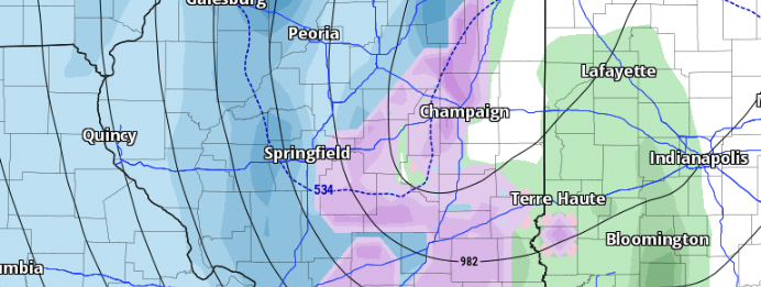
Initial projections indicate that snow will reach Western Illinois between 3-6 PM on Monday, January 8th. Temperatures are expected to be borderline at the onset of snow, so a wintry mix is possible during the first few hours as the atmosphere cools and becomes favorable for snow. Moving into the overnight hours, significant wet snow is expected from a Champaign-to-Springfield line and northward. During this period, winds are projected to gust between 35-40 mph, potentially leading to intermittent blizzard conditions.

Envision a break in precipitation as the low traverses the state on Monday night. Following the departure of the low center, expect snow to the north of a Springfield-to-Chicago line and rain to the south, with temperatures rising above freezing.
As the low moves away and temperatures drop below freezing across the entire area, we can predict the resumption of snowfall over much of the state.
Anticipate the highest snowfall totals to be from Quincy to Peoria to Chicago and northward, with a sharp decrease as you move south of that line. High winds will be a concern through the whole event and could lead to power outages, especially where heavy wet snow falls.
Another concern is wind-chill values as the low departs and colder temperatures filter in with winds gusting to 35-40 mph. brining wind-chill values down into the single digits for some.

Takeaways
- Heavy Snow North and West of a Quincy-Peoria-Chicago Line (3-5″)
- Heavy rain for areas that dont see snow (1-2″ of rain)
- High winds between 35-40 mph could create power issues with heavy wet snow
- Track can change and so can the forecast
This system is still evolving, and we can expect changes in the forecast regarding the placement of the heaviest snow. A northward shift would relocate the heaviest snow to the northwest, while a southward shift would push the heaviest band further south. I will continue to monitor and provide updates.
Leave a Reply