-
Weekly Weather Outlook 1.7.24
It’s Sunday, and it’s time for our weekly forecast update. We’ve got a busy week ahead with significant weather developments.
-
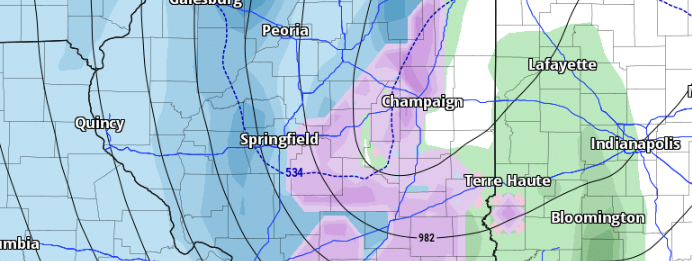
Winter Storm 1.8.24
A robust winter storm is forecasted to sweep through the state starting Monday night. Expect high winds exceeding 35 mph, substantial snowfall in certain areas, and rainfall.
-
Snowfall from 1/5/2024
A fast-moving clipper brought accumulating snow to areas of Central Illinois on the night of January 5, 2024. The forecast called for 1-2 inches for areas between I-55 and I-74, and this was verified, with some locations picking up almost 3.5 inches of snow.
-
Forecast Update 1/5/24
We’re anticipating a busy few days ahead here in Illinois as two weather systems traverse the state. The initial system is set to pass through tonight (Friday), bringing with it the possibility of light accumulating snow in certain areas. The second system, which has been closely monitored for its potentially more significant impacts, is on…
-
Light Snow Friday Night
Attention has been on the system for early next week, but we can’t get too focused on it and let our first system catch us off guard. We have a low-pressure system moving to the south of Illinois Friday night. This will bring light snow to south-central and southern Illinois.
-
Watching Next Week
A potent low-pressure system will bring unsettled weather to Illinois Monday night into Tuesday. There is still uncertainty as to where the low will track, but models have shown the low tracking through Central Illinois. Where the low tracks will have a significant impact on the forecast from Monday into Wednesday.
-
Weekly Outlook 1/2/2024
We begin the week with dry conditions as an area of high pressure dominates our weather for the first part of the week. A weak cold front is expected to push through the area on Tuesday, bringing a low chance for some light snow or freezing drizzle.
-
Unsettled Weather 1/1/24
We have a few weather systems to keep an eye on over the next several days for us here in IL. The first system to watch looks to bring unsettled weather to the area over the weekend 1/5 through 1/7.
-
Winter Weather 12-28-23
A Winter Weather Advisory is in effect for portions of NW IL from 9 am to 9 PM today. 1-3” of snow expected.
-
Bouts of Snow Possible
A few rounds of snow will be possible Wednesday into Thursday as an upper-level wave moves through the area. I am not currently anticipating a significant snowfall from this, but some locations could pick up a couple of inches of snow.