Category: Weather Update
-
Super Harvest Moon and Partial Lunar Eclipse Tonight
Tonight, the Super Harvest Moon will be visible, marking the full moon closest to the Autumnal Equinox. As a Supermoon, it will appear slightly larger and brighter than usual, about 5% bigger and 13% brighter.
-

Northern Lights make an appearance
Last night, around 10:25 PM, the northern lights made a subtle appearance over Central Illinois. A faint red glow was visible to the naked eye for a brief period, adding an unexpected touch of color to the evening sky.
-
Effingham Forecast
-
Eclipse 2024
The much anticipated solar eclipse on April 8th is inching closer. What can you expect? If you find yourself within the path of totality, prepare for a total solar eclipse lasting anywhere from just under 1 minute to over 3.5 minutes. For those outside this path, your experience will vary depending on your location and…
-
Heavy Rain Monday
Heavy rain and high winds are expected on Monday across the Pana area. Current model guidance suggests around 1.00″ of rain is possible, and areas West of a Taylorville to the Decatur line could see higher amounts, upwards of 1.50″.
-
2-27-24 Severe Weather Threat
As of 7:00 AM, the Storm Prediction Center has a slight risk for severe thunderstorms across a significant portion of Illinois. The region is characterized by a complex atmospheric setup, posing the potential for large hail, damaging winds, and a few tornadoes.
-
Heavy Snow, Strong Winds, bitter temps
Merely days following the recent system that brought up to 10 inches of snow to the state, we are now anticipating another significant weather system poised to bring substantial snowfall and strong winds to the region, commencing Thursday evening.
-
Winter Storm 1.8.24
A robust winter storm is forecasted to sweep through the state starting Monday night. Expect high winds exceeding 35 mph, substantial snowfall in certain areas, and rainfall.
-
Forecast Update 1/5/24
We’re anticipating a busy few days ahead here in Illinois as two weather systems traverse the state. The initial system is set to pass through tonight (Friday), bringing with it the possibility of light accumulating snow in certain areas. The second system, which has been closely monitored for its potentially more significant impacts, is on…
-
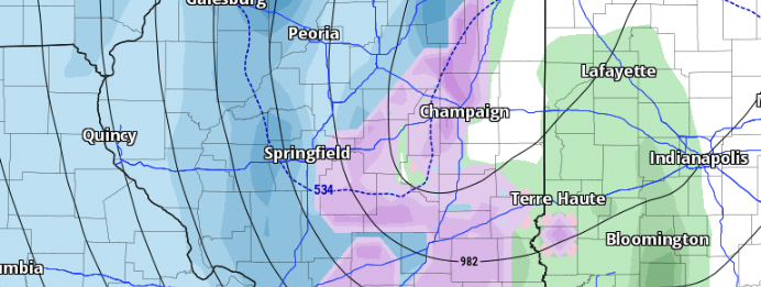
Light Snow Friday Night
Attention has been on the system for early next week, but we can’t get too focused on it and let our first system catch us off guard. We have a low-pressure system moving to the south of Illinois Friday night. This will bring light snow to south-central and southern Illinois.