Category: illinois
-
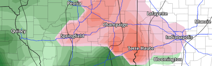
Severe Weather Threat 4-1-2024
Much of Central and Southern Illinois is once again under the threat for severe thunderstorms this evening into the overnight hours. The SPC has a level 3 of 5 Enhanced risk for portions of South-Central and Southern Illinois and a level 2 of 5 Slight risk for areas South of a Bloomington Peoria Line.
-
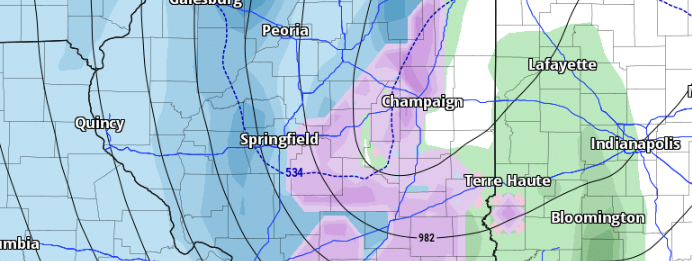
March 14, 2024 Severe weather overview.
Severe thunderstorms overspread portions of Central and South-Central IL during the afternoon and evening hours of March 14, 2024. The Storm Prediction Center issued a tornado watch for much of Central Illinois and South-Central IL until 9 PM.
-
Freezing Rain Possible Monday
Freezing rain could occur on Monday into Monday night north of I-70. Current model guidance suggests that areas north of I-70 in the state may experience up to 1/10th of an inch of freezing rain. While an ice storm is not anticipated, even small amounts of ice could pose travel challenges during Monday and Monday…
-
Heavy Snow, Strong Winds, bitter temps
Merely days following the recent system that brought up to 10 inches of snow to the state, we are now anticipating another significant weather system poised to bring substantial snowfall and strong winds to the region, commencing Thursday evening.
-
Weekly Weather Outlook 1.7.24
It’s Sunday, and it’s time for our weekly forecast update. We’ve got a busy week ahead with significant weather developments.
-
Winter Storm 1.8.24
A robust winter storm is forecasted to sweep through the state starting Monday night. Expect high winds exceeding 35 mph, substantial snowfall in certain areas, and rainfall.
-
Forecast Update 1/5/24
We’re anticipating a busy few days ahead here in Illinois as two weather systems traverse the state. The initial system is set to pass through tonight (Friday), bringing with it the possibility of light accumulating snow in certain areas. The second system, which has been closely monitored for its potentially more significant impacts, is on…
-
Watching Next Week
A potent low-pressure system will bring unsettled weather to Illinois Monday night into Tuesday. There is still uncertainty as to where the low will track, but models have shown the low tracking through Central Illinois. Where the low tracks will have a significant impact on the forecast from Monday into Wednesday.
-
Weekly Outlook 1/2/2024
We begin the week with dry conditions as an area of high pressure dominates our weather for the first part of the week. A weak cold front is expected to push through the area on Tuesday, bringing a low chance for some light snow or freezing drizzle.
-
Unsettled Weather 1/1/24
We have a few weather systems to keep an eye on over the next several days for us here in IL. The first system to watch looks to bring unsettled weather to the area over the weekend 1/5 through 1/7.